
| PHOTOS & LINKS |
|---|
The Dam Project
The Proposed Dam and Inundation:
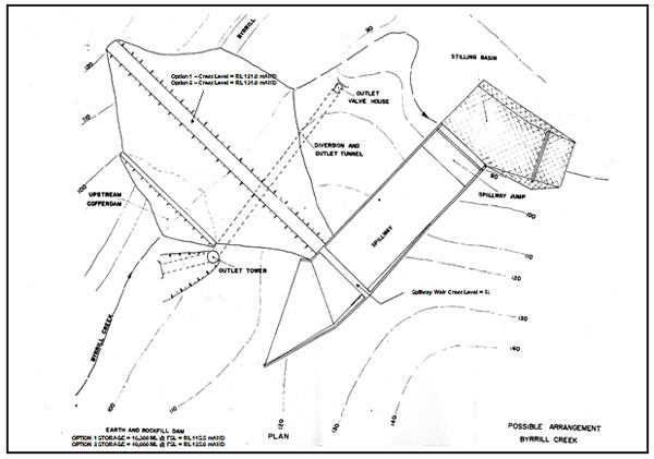
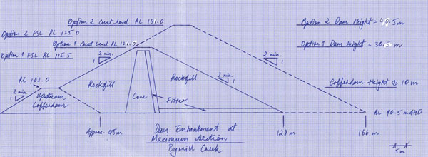
The dam wall would be located at Byrrill Lagoon which is Platypus habitat. It would be an earth & rock fill dam with the spillway height at 40 mts high, (contour level 125-130mts) and 50 mts wide.
The catchment area is 53 square km. There are 2 options for dam size. For the larger dam of 36,000ML the amount of land inundated is 400ha and for the smaller dam of 16,000ML 240ha would be flooded.
6 dwellings would be flooded, one of them council owned. The dam would affect 24 land owners. The dam does not just flood Byrrill Creek valley, but also Kunghurloo & parts of Mebbin Springs. Access roads to 19 people's property would be affected. Local knowledge portrays different statistics to that of the Council.
The road west to Tyalgum would be severed & due to terrain and cost, it probably would not be replaced. Many people who live on the Tyalgum end of Byrrill Creek would lose their access to Uki & Kyogle road. Access to Mebbin National Park would be via Tyalgum, or Cadell Rd, and the Camp ground would not be accessible, unless a bridge was built, which is highly unlikely.
Geology
Investigations in 1977 revealed rock types at the site consisting of interlayered gently dipping sandstone and near horizontal dolerite sills. Except for minor outcrops of dolerite in the creek bed, the site is covered with residual soils. The abutments are characterised by deep weathering with the dolerites providing rock with any great strength. High leakage conditions have been encountered in the proposed embankment foundations, particularly on the left abutment. Construction rockfill materials would need to be imported from an outside quarry although earthfill would be available within the dam storage and spillway excavations.
The geologist's report concludes as follows:
Byrrill Creek site has some severe geological problems, the main one being the considerable depth of weathering on each abutment. The resultant clayey soil and highly weathered material would make it very difficult to design an effective or economical cut-off structure. The deep weathering in each abutment also commits the site to a fully lined spillway. An extensive program of grouting would be required to establish an effective grout curtain.
BACKGROUND AND HISTORY OF THE PROPOSED BYRRILL CREEK DAM AREA
Timeline of Events & Background On Proposed Byrrill Creek Dam:
1977 Reconnaissance Engineering Geological Survey of NSW, & Dept Public Works NSW
1978 Geological Survey of NSW, Feasibility investigation on Byrrill & Doon Doon Site
1980-1982 Clarrie Hall dam built for Tweed Water Supply
1983- Caveats placed on affected land in Byrrill Creek from this date.
1986 -Council purchases Wades land (1,131ha) at back end of Byrrill Creek. Land leased to Ken Morrow for cattle adgistment.
1993- Joint NSW Forestry & Council Forestry Plantation on 230ha of the land. Maturity 25-30yrs
1998- 2000 Council plants an extra 107ha & 56 ha
2004- NSW Dept Commerce: Construction of Byrrill Creek Dam & Cost estimate for 16,000ML dam
2007- SMEC commissioned to investigate dam at Rocky Cutting, Eungella
2007- Byrrill Creek Dam @ 16,300ML costed at $38.3 million. Tweed Shire Council implements studies for extra water supply.
2009 October- NSW Dept Works (designer of Clarrie Hall Dam) commissioned to look at a larger 40,000 ML dam at Byrrill creek with estimated cost initially @$51 million, & now @ $58.4 million
2009- The Tweed River Area Unregulated & Alluvial Draft Water Sharing Plan is released with a prohibition on dams in Byrrill Creek & the Mid Tweed River.
2009 October- Tweed Council puts in an amendment to the prohibition to allow for town water supply.
2009 December- March 2010- TSC begins Community Consultation process on 4 Selected Options for new Water Supply with CWG members. The majority of CWG members do not support Byrrill Dam due to environmental significance & prohibition within the Draft Water Plan.
2010 April- Community Working Group [CWG] report is released asking for an independent review of the councils Demand Management Strategy prior to implementing any of the water supply options.
2010 October 19th Tweed Shire Council votes on Water Supply Options. Byrrill Creek dam moved from 3rd option to !st option. Recision motion put foward by 3 councilors.
2010 November 1st extraordinary council meeting maintains Byrrill Creek as 1st option.
2010 December New Tweed River Area Unregulated & Alluvial Water Sharing Plan is due to be gazetted
Pre Approval Plan
WaterSupply Augmentation |
Time estimate |
Preliminary estimate |
Outcome from deliverable |
Timing / Sceduling constraints |
|||||
Concept Design for Augmented Water Supply |
$400,000 |
||||||||
Concept Design |
|||||||||
Storage Concept Design |
180 days |
Improved understanding of dam size required (FSL) and moreaccurate cost estimates |
Requires geotech, seismic, survey andhydrological studies |
||||||
Project Infrastructure Concept Design |
Improved understanding of road, bridge and infrastructurerelocations required and more accurate cost estimates |
Requires FSL height and survey |
|||||||
Geological / Geotech Studies ? PrelimImmediate Start |
90 days |
Improved understanding of ground conditions??> influence concept design |
immediate start |
||||||
Seismic StudiesImmediate Start |
60 days |
Input to concept design |
immediate start, requires geotech studies |
||||||
Survey |
90 days |
Input to hydrology study and concept design |
immediate start |
||||||
Hydrology Studies ? transmission losses? initial enviro flow estimates Immediate Start |
90 days |
Improved understanding of dam size required, efficiency ofoperation ??> influence concept design |
requires direction from governmentagencies to develop possible prelim enviro flow scenarios |
||||||
Environmental Assessment |
$1,000,000 |
||||||||
Legal & Planning AdviceImmediate Start |
120 days |
Improved understanding of likely planning, licensing andoperating legal and legislative issues ??> influence environmental studies approach, EP&A approval path, EPBC requirements, may highlight "show?stopper" issues |
immediate start |
||||||
Environmental Flow Studies ? detailed |
400 days |
Improved understanding of environmental flow requirements??> influence neogitations with Govt Agencies ??> input to EIS, Final Hydrological study & Detailed Design |
Long investigation period ? up to 2yrs ?over several seasonal (and potentially annual) variations |
||||||
Environmental Impact Assessment |
250 days |
||||||||
Soils, Landform Stability and Erosion Hazard |
Input to EIS |
||||||||
Terrestrial Ecology |
Input to EIS??> define EPBC requirements ??> influence EP&A, Detailed design, may highlight "show stopper" issues |
Long investigation period ? poss 12 mnths? over several seasons |
|||||||
Aquatic Ecology |
Input to EIS??> define EPBC requirements ??> influence EP&A, Detailed design, may highlight "show stopper" issues |
Long investigation period ? poss 12 mnths? over several seasons |
|||||||
Flora and EECs |
Input to EIS??> define EPBC requirements ??> influence EP&A, Detailed design, may highlight "show stopper" issues |
Long investigation period ? poss 12 mnths? over several seasons |
|||||||
Cultural Heritage Study |
120 days |
Improved understanding of cultural heritage significance??> define compensatory costs ??> influence EP&A, Detailed design, may highlight "show stopper" issues |
Relatively short investigation,consultation and reporting periods |
||||||
Noise and Vibration |
understand construction issues |
||||||||
Water Quality (Surface and Groundwater) |
? |
||||||||
Riverbed and Bank Stability, Sediment Transport |
? |
||||||||
Groundwater, Surface Water and Extraction |
? |
||||||||
Air Quality |
understand construction issues |
||||||||
Traffic, Access and Amenity |
understand construction issuesunderstand road closure issues |
||||||||
Waste and Resource Use |
understand construction issues |
||||||||
Economic and Social Impacts |
? |
||||||||
Visual and Aesthetic |
? |
||||||||
Recreational |
? |
||||||||
Energy and Greenhouse |
understand construction issues |
||||||||
Climate Change |
hydrology issues |
||||||||
Community Consultation |
? |
||||||||
Cumulative Impacts and Benefits |
? |
||||||||
Negotiations with Government Agencies |
$150,000 |
||||||||
NPWS ? Revocation of NP land (incl. Act of Parliament)Immediate start |
300 days |
determine process, stakeholders, contacts, and likely timeframe& compensation for revocation of NP land |
Long negotiation period ? potentially overseveral years |
||||||
Planning Approval Requirements |
|||||||||
EIS requirements (initial contact)Immediate start |
60 days |
determine process, stakeholders, and studies required ? willassist define EIS brief ??> informal feedback on likelihood of success / "show stopper" issues?? |
immediate start |
||||||
Adaptive Management requirements (initial contact)Immediate start |
90 days |
determine process, stakeholders, and studies required ? willassist define EIS brief ??> informal feedback only?? ??> estimate of likely ongoing costs?? |
immediate start |
||||||
Water Sharing PlanImmediate start |
negotiate with Water Minister, determine likely enviro flowrequirements |
immediate start |
|||||||
Fisheries requirementsImmediate start |
understand probable enviro flow regimes, fish passage,compensatory costs, |
immediate start |
|||||||
EPBC approval |
60 days |
? |
refer legal assessment |
refer legal assessment |
|||||
Pre?construction Licenses |
$2,000,000 |
||||||||
Development of documentation for additional approvals |
250 days |
? |
|||||||
Approvals: Water Supply (s90 WMAct 2000), Fisheries, NP |
200 days |
? |
|||||||
Bio?banking / Compensatory habitat (NPWS) |
? |
||||||||
Land Acquisitions |
$50,000 |
||||||||
Acquisitions PlanImmediate start |
120 days |
Improve understanding of areas to be acquired, approaches tonegotiations, purchase costs, other compensation costs, identify owners of most need, likely timings ??> reduces uncertainties felt by landholders |
immediate start, but will require FSLheight to finalise |
||||||
Negotiations and acquisitions |
300 days |
? |
? |
||||||
$3,600,000 |
|||||||||